Japan was on alert for landslides and flooding Thursday as a strong typhoon headed towards Tokyo with downpours and gusts to disrupt air and land traffic.
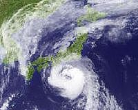
Typhoon Fitow, packing winds of up to 126 kilometres (78 miles) an hour near its centre, was in the Pacific and some 500 kilometres south of Tokyo Thursday morning, the meteorological agency said.
Television footage showed towering waves around Hachijojima, a small Pacific island, and swollen rivers in parts of mainland Japan.
The storm is forecast to weaken slightly by the time it will make landfall in Japan.
However, if the typhoon maintains its current force, it would be the strongest to hit Japan since a October 2004 typhoon that killed dozens of people, according to the agency.
Moving north slowly at 20 kilometres an hour, it was whipping up six-metre (20-foot) high waves near Hachijojima, the agency said.
The storm is forecast to reach Tokyo and its vicinity by early Friday.
"Given the slow speed of the typhoon, we have to brace ourselves for heavy rainfall and strong winds that last for a long time," which increases chances of landslides and flooding, an agency official said.
Railway services were partially suspended in provinces north of Tokyo due to rain while a dozen flights between Hachijojima and Tokyo's Haneda airport were cancelled.
Coastal expressways were also partially closed due to high waves.
Fitow is the name of a flower found in Micronesia.
Typhoons hit Japan in July and August, killing several people and injuring dozens.
